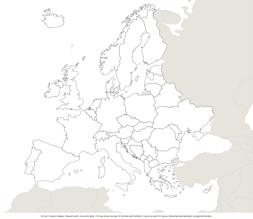
The quiz names a country and the answer is a tap on the map, one country after another until all 45 have been asked. No account is needed. The smallest countries carry a marker, and on a phone the map zooms in where a tap would otherwise miss. Under the map come the list of countries, their capitals and the rules the borders follow.
How the Europe map quiz works
- The prompt above the map reads "Find:" followed by a country name. The countries come in random order.
- Tap or click the country on the map. With the keyboard, Tab moves between countries and Enter or Space gives the answer.
- The country that was asked for turns green after a correct tap and red after a wrong one, so the right answer stays visible either way.
- Very small countries have a marker. A tap near one of them zooms the map in by a factor of three, and a second zoom is possible if needed. In the zoomed view the tap on the country or its marker counts as the answer, and a Zoom out button returns to the full map. After every answer the map goes back to the full view.
- The score line shows the correct answers and the number of questions asked. At the end the quiz shows the result out of 45 and lists the countries to review. New round starts again with a fresh order.
The zoom exists for countries that are too small to hit on a phone. At a screen width of 390 pixels, 24 of the 45 countries are small enough to receive a marker. Six of them have a longest side under 3 CSS pixels: Vatican City (0.09), Monaco (0.36), San Marino (0.77), Liechtenstein (1.77), Andorra (2.04) and Malta (2.63). In testing, an answer took 1.78 taps on average at phone width and 1.16 at desktop width.
The quiz runs in the browser and needs JavaScript. Without it the prompt says so, and the lists below the map remain readable.
Countries in the Europe quiz map
The quiz asks for 45 countries. The groups in the table follow the United Nations geoscheme (M49), which divides Europe into Eastern, Northern, Southern and Western Europe. The UN adds that such groupings are "for statistical convenience" and imply no political or other affiliation.
| Region | Number | Countries in the quiz |
|---|---|---|
| Eastern Europe (UN) | 9 | Belarus, Bulgaria, Czechia, Hungary, Moldova, Poland, Romania, Slovakia, Ukraine |
| Northern Europe (UN) | 10 | Denmark, Estonia, Finland, Iceland, Ireland, Latvia, Lithuania, Norway, Sweden, United Kingdom |
| Southern Europe (UN) | 15 | Albania, Andorra, Bosnia and Herzegovina, Croatia, Greece, Italy, Malta, Montenegro, North Macedonia, Portugal, San Marino, Serbia, Slovenia, Spain, Vatican City |
| Western Europe (UN) | 9 | Austria, Belgium, France, Germany, Liechtenstein, Luxembourg, Monaco, Netherlands, Switzerland |
| Western Asia (UN) | 1 | Cyprus |
| Not in the UN scheme | 1 | Kosovo |
The list was derived from the UN scheme, which has 51 entries for Europe. Seven of them are territories and special cases (Åland, Faroe Islands, Guernsey, Isle of Man, Jersey, Svalbard and Gibraltar), and one is Russia. That leaves 43 countries. Cyprus, which the UN counts in Western Asia, and Kosovo, which the scheme does not list, bring the total to 45.
Russia is not in the quiz, although the UN places it in Eastern Europe. Türkiye, Georgia, Armenia, Azerbaijan and Kazakhstan are left out because the UN counts them in Asia; they appear in the Asia map quiz instead. Country names use common short forms, such as Czechia, Moldova, Vatican City, Netherlands, United Kingdom and North Macedonia.
Borders and disputed cases on the map
The map follows internationally recognized borders. Three cases show what that means in practice.
Crimea belongs to Ukraine on the map. On March 27, 2014, UN General Assembly Resolution 68/262 affirmed the sovereignty and territorial integrity of Ukraine "within its internationally recognized borders" and held that the referendum held in Crimea and Sevastopol on March 16, 2014 had no validity. The vote was 100 in favour, 11 against and 58 abstentions.
Northern Cyprus is drawn as part of Cyprus. Security Council Resolution 541 of 1983 called the declaration of a state in the north legally invalid and asked all states not to recognize any Cypriot state other than the Republic of Cyprus. That text is taken from a reproduction on un-project.org, as the UN's own copy could not be opened.
Kosovo is a separate area. It does not appear in the UN geoscheme, whose notes say its status is to be understood in the context of Security Council Resolution 1244 (1999). On July 22, 2010, the International Court of Justice stated in an advisory opinion that the declaration of independence of February 17, 2008 did not violate international law. Kosovo is recognized by some states and not by others, and the quiz treats it as an area of its own.
Western and Eastern Europe on the map
The quiz has no separate rounds for Western or Eastern Europe. All 45 countries are asked in a single round, and the table above shows which region each belongs to.
The UN's Western Europe is a small group of nine countries: Austria, Belgium, France, Germany, Liechtenstein, Luxembourg, Monaco, the Netherlands and Switzerland. The everyday meaning of the term is usually wider. Spain, Portugal and Italy count as Southern Europe in the UN scheme, and the United Kingdom and Ireland as Northern Europe, so a map of Western Europe in the loose sense mixes several UN groups.
Eastern Europe has ten entries in the UN scheme. Nine of them are in the quiz: Belarus, Bulgaria, Czechia, Hungary, Moldova, Poland, Romania, Slovakia and Ukraine. The tenth is Russia, which the quiz does not ask for.
Europe map quiz with capitals
The quiz asks for countries, not capitals. The capitals are in the table below, as they appear in the U.S. State Department's list of independent states in the world, which was current on August 11, 2026. Reykjavík is written with its accent, and Monaco, San Marino, Luxembourg and Vatican City are listed with a capital of the same name as the country. For the Netherlands the list gives Amsterdam as the capital and The Hague as the seat of government. Kosovo's capital is Pristina; the State Department notes that Kosovo is not a UN member, and recognition by other states varies. The states and capitals quiz covers the American counterpart.
| Country | Capital |
|---|---|
| Albania | Tirana |
| Andorra | Andorra la Vella |
| Austria | Vienna |
| Belarus | Minsk |
| Belgium | Brussels |
| Bosnia and Herzegovina | Sarajevo |
| Bulgaria | Sofia |
| Croatia | Zagreb |
| Cyprus | Nicosia |
| Czechia | Prague |
| Denmark | Copenhagen |
| Estonia | Tallinn |
| Finland | Helsinki |
| France | Paris |
| Germany | Berlin |
| Greece | Athens |
| Hungary | Budapest |
| Iceland | Reykjavík |
| Ireland | Dublin |
| Italy | Rome |
| Kosovo | Pristina |
| Latvia | Riga |
| Liechtenstein | Vaduz |
| Lithuania | Vilnius |
| Luxembourg | Luxembourg |
| Malta | Valletta |
| Moldova | Chisinau |
| Monaco | Monaco |
| Montenegro | Podgorica |
| Netherlands | Amsterdam (seat of government: The Hague) |
| North Macedonia | Skopje |
| Norway | Oslo |
| Poland | Warsaw |
| Portugal | Lisbon |
| Romania | Bucharest |
| San Marino | San Marino |
| Serbia | Belgrade |
| Slovakia | Bratislava |
| Slovenia | Ljubljana |
| Spain | Madrid |
| Sweden | Stockholm |
| Switzerland | Bern |
| Ukraine | Kyiv |
| United Kingdom | London |
| Vatican City | Vatican City |
Blank Europe map for a quiz
A blank version of the map sits under the quiz as a PDF and an SVG. The PDF is a single page in Letter size, landscape. It shows the country outlines without names, so it can be filled in by hand and checked against the table of capitals above. Crimea appears as part of Ukraine and Northern Cyprus as part of Cyprus, as on the quiz map. The SVG is a vector file, so it can be enlarged for a classroom wall without losing sharpness.
How the map and the list were built
The country shapes come from Natural Earth, distributed as TopoJSON in the world-atlas package, version 4.1.0 of the data, under the ISC license. Natural Earth draws borders according to their de facto status, and its terms place the data in the public domain. Because the borders here follow the recognized ones, Crimea and Northern Cyprus were corrected by hand.
The list of 45 comes from the derivation in the countries section and matches the 45 selectable shapes on the map. In tests with real taps at screen widths of 320, 390 and 1,280 pixels, every country could be reached. Capitals come from the State Department list named above.
Frequently asked questions
01Which countries are included in the Europe map quiz?
The quiz covers 45 countries: all the countries the United Nations lists in Europe except Russia, plus Cyprus and Kosovo. Türkiye, Georgia, Armenia, Azerbaijan and Kazakhstan are not part of it, because the UN counts them in Asia. The full list sits below the map, sorted by region.
02Is there a Europe map quiz with capitals?
The quiz asks for countries by name and has no capital mode. Each country's capital is listed in a table on the page, and the blank Europe map can be printed and filled in by hand.