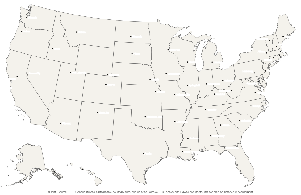
The map draws the 50 states in outline and puts a point and a name on every capital. Washington, D.C. is not on it, because it is a federal district and not a state. The complete list of states and capitals with a filter gives the same pairs in table form, and the downloads below turn the map into a sheet of paper.
Where are the 50 state capitals on the map?
The map is read best one region at a time. The Census Bureau groups the states into the Northeast with nine states, the Midwest with twelve, the South with sixteen and the West with thirteen, which makes 50. The South is the widest band, running from Delaware and Maryland on the Atlantic coast to Texas and Oklahoma in the west, and the West includes Alaska and Hawaii, which sit in boxes under the southwest corner.
| Region | States |
|---|---|
| Northeast | 9 |
| Midwest | 12 |
| South | 16 |
| West | 13 |
A capital is not always in the middle of its state, and the map shows this clearly. Carson City sits at the western edge of Nevada, close to the California line. Cheyenne lies in the southeast corner of Wyoming, and Lincoln in the southeast of Nebraska. Topeka is in the northeast of Kansas, and Tallahassee is in the far north of Florida. Juneau lies in the southeast of Alaska, far from the center of the state. The positions were fixed by history and geography, not by symmetry.
For the full list in alphabetical order with all postal codes, see the complete list of states and capitals.
Which capitals are hard to find on the map?
The difficulty is mostly a question of size. Rhode Island is the smallest state, with 1,545 square miles of total area including water, according to the 2010 Census reference table, and its capital Providence sits among the other small states of the Northeast. On a phone screen 390 pixels wide, ten states are too small to hit reliably: Indiana, Massachusetts, New Jersey, Connecticut, Delaware, Maryland, New Hampshire, Tennessee, Vermont and Rhode Island.
The map deals with this in two ways. Those states carry a marker that is easier to hit than the shape itself. A tap near a cluster of small states zooms the view in by a factor of three, and once more if it is still too crowded, after which the choice is made on the enlarged map. A button returns to the full view. Selection also works from the keyboard, by moving to a state with the Tab key and pressing Enter.
The printed map has its own tight spots. Along the east coast and around Maryland the capital names sit close together, and the PDF is best printed at full size to keep them readable. The SVG can be enlarged further without loss.
Download the US map with capitals
The map comes in two files. The PDF is one landscape page in Letter size, ready for a printer. The SVG is a vector drawing that scales to any size and opens in a browser or a vector program. Both show the same outlines and the same 50 points and names, and the file sizes are printed beside the buttons. The states are filled in a light warm gray with thin borders, and each capital is a small black dot with its city name beside it.
The capitals map names only the cities. State names are left off so the map doubles as a test. A map with the states named, a map with postal abbreviations and a blank version are in the set of printable US maps, which also explains how to choose between PDF and SVG.
Can you print the map as a study sheet?
Yes, and the set around it is built for that purpose. The capitals map serves as the answer sheet. Next to it, the printable maps include a blank outline to fill in, a version with the state names and a quiz sheet whose states are numbered 1 to 50, together with an answer key. That combination covers a full cycle: learn from the labeled map, test on the blank one, mark against the key.
All PDFs are the same format, one landscape Letter page, so a set prints as a stack of identical sheets. Each sheet carries a source line along the bottom edge. The details of the variants are on the page for printable US maps.
Can you test yourself on the capitals?
The states and capitals quiz uses the same map outlines. It names a capital, asks which state has it, and takes the answer as a tap on the map. A round covers all 50 states in random order. Right answers turn green, wrong ones red, and the round ends with a score and a list of the states that were missed.
The quiz is a separate page rather than a feature of this one. This page is for looking things up, with every capital visible at once. The quiz hides the answers. The list page offers a short practice round of ten questions in which the capital is typed in instead of tapped, a different way to work on the same pairs.
How are Alaska and Hawaii shown?
The maps use a composite projection that draws the 48 contiguous states in one frame and sets Alaska and Hawaii in insets under the southwest. Alaska is drawn at 0.35 of the scale used for the other states. That matters for any reading of size: Alaska is the largest state, with 665,384 square miles of total area including water against 268,596 for Texas, the second largest, and on the map it looks much smaller. The figures are Census Bureau reference values from 2010.
The map is for locating capitals. It is not meant to compare areas or measure distances.
Where do the capital points come from?
The capital points use the coordinates of the dataset behind the states and capitals list. All 50 points were tested against the state outlines and lie inside the correct state. Compared with the centre points the Census Bureau lists for the municipalities, the coordinates differ by 2.4 km at the median and by up to 16.2 km for Juneau, in a comparison of 49 of the 50 capitals. They are reference positions for a map at this size, not surveyed locations. Each point is stored in the same drawing coordinates as the outlines, so a point and its state scale together when the SVG is enlarged.
The pairs of states and capitals were matched with the state list in the style manual of the U.S. Government Publishing Office, and all 50 agree. The outlines are the Cartographic Boundary Files of the U.S. Census Bureau, 2017 edition, redistributed by the us-atlas package and drawn with the d3 geoAlbersUsa projection.
Capitals of the territories are not part of this map. They are covered under US territories.
Frequently asked questions
01Is there an interactive US map with capitals?
Yes. Every state on the map can be selected, and a line above the map then shows the state name, its postal code, its capital and the coordinates of the capital point. On phones, states that are too small to hit are marked, and a tap near them zooms the map in so the right state can be chosen.
02Is there a printable map of US states and capitals?
Yes. The capitals map comes as a PDF on one landscape Letter page and as an SVG. It marks and names all 50 capitals. The printable maps page adds blank, abbreviation and state-name variants for use alongside it.
03Is there a quiz for states and capitals on a map?
Yes. The states and capitals quiz names a capital and asks which state has it. The answer is a tap on the map, a round covers all 50 states in random order, and the score appears at the end together with the states that were missed.
04Is there a US map with capitals and cities?
The map shows the 50 state capitals. Larger cities that are not capitals, such as Los Angeles or Chicago, are not on it yet, so there is no version with major cities.