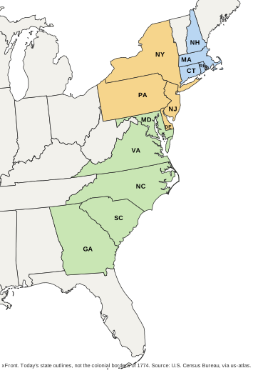
The thirteen colonies were the British colonies along the Atlantic coast of North America that stood behind the Declaration of Independence of July 4, 1776. The document speaks for "the thirteen united States of America", and those thirteen became the first states of the Union.
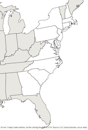
The outlines on the map are today's state borders. They show where the original states are now, not what each colony covered, and the difference is large in places. The Senate Manual gives Virginia 61,352 square miles in 1788 and 40,767 today. A few present-day states were cut from colonial land and are not highlighted; they are named further down.
Which were the 13 colonies, and what are they called today?
All thirteen still exist, as states, so the question is mostly about names. Massachusetts Bay is Massachusetts today; the others kept the name of the colony. In their own time the colonies often went by longer formal names. Wikipedia lists, among others, the Province of Massachusetts Bay, the Delaware Colony and the Colony of Rhode Island and Providence Plantations.
The table gives each colony with its region and the date it ratified the Constitution, as listed in the Senate Manual.
| Colony | Region | State today | Ratified the Constitution |
|---|---|---|---|
| New Hampshire | New England | New Hampshire | June 21, 1788 |
| Massachusetts Bay | New England | Massachusetts | February 6, 1788 |
| Rhode Island | New England | Rhode Island | May 29, 1790 |
| Connecticut | New England | Connecticut | January 9, 1788 |
| New York | Middle colonies | New York | July 26, 1788 |
| New Jersey | Middle colonies | New Jersey | December 18, 1787 |
| Pennsylvania | Middle colonies | Pennsylvania | December 12, 1787 |
| Delaware | Middle colonies | Delaware | December 7, 1787 |
| Maryland | Southern colonies | Maryland | April 28, 1788 |
| Virginia | Southern colonies | Virginia | June 25, 1788 |
| North Carolina | Southern colonies | North Carolina | November 21, 1789 |
| South Carolina | Southern colonies | South Carolina | May 23, 1788 |
| Georgia | Southern colonies | Georgia | January 2, 1788 |
How were the 13 colonies grouped into three regions?
The usual split has three groups. New England holds New Hampshire, Massachusetts Bay, Rhode Island and Connecticut. The Middle Colonies are New York, New Jersey, Pennsylvania and Delaware. The Southern Colonies are Maryland, Virginia, North Carolina, South Carolina and Georgia. That gives 4, 4 and 5, and the colors on the map follow it. Wikipedia calls this the traditional grouping.
Sources differ on one colony. A National Park Service lesson plan places Maryland with the middle colonies, next to New York, New Jersey, Pennsylvania and Delaware, and leaves Virginia, North Carolina, South Carolina and Georgia as the south. That makes the split 4, 5 and 4. A worksheet built on the NPS version colors Maryland differently from the map here, so it is worth checking which grouping a class is using. Rhode Island and Delaware, the smallest states on the map, are also the last and the first to ratify, which makes a handy way to remember the two ends of the ratification order.
In what order were the colonies founded, and in what order did they become states?
Two separate orders tend to get mixed up. The first concerns the colonies. Virginia is the oldest: in 1607, through the Virginia Company, England established its first permanent colony at Jamestown, in the words of the National Park Service. Georgia is the youngest. The Georgia Historical Society dates its charter, signed by King George II, to 1732, and the first settlers arrived on February 12, 1733. The year 1732 therefore marks the charter, not the start of settlement. Georgia is the answer when someone asks for the thirteenth colony.
The second order concerns the states. Delaware ratified the Constitution first, on December 7, 1787, and Rhode Island last, on May 29, 1790. The full sequence:
- Delaware
- Pennsylvania
- New Jersey
- Georgia
- Connecticut
- Massachusetts
- Maryland
- South Carolina
- New Hampshire
- Virginia
- New York
- North Carolina
- Rhode Island
Georgia, the last colony founded, was the fourth to ratify. The dates come from the Senate Manual. Ben's Guide to U.S. Government, published by the Government Publishing Office, gives the same order but dates North Carolina's ratification to November 21, 1788; the Senate Manual says 1789, and the table follows it.
What does the ratification date on the map mean?
The date shown for each state is not the date of independence. The thirteen acted together in 1776, when the Declaration of Independence spoke for "the thirteen united States of America", and the Treaty of Paris of September 3, 1783 ended the American Revolution. The Constitution came later, and each state accepted it through its own ratification, which is why the dates run over almost three years, from December 7, 1787 to May 29, 1790.
Article VII of the Constitution made the approval of nine states enough for it to take effect between those states. Ben's Guide to U.S. Government marks New Hampshire, on June 21, 1788, as the ninth. North Carolina followed on November 21, 1789 and Rhode Island on May 29, 1790, the last of the thirteen. A ratification date therefore says when a state joined the new constitutional system, which is a separate fact from the year its colony was founded.
How did 13 colonies become 50 states?
- July 4, 1776: the Declaration of Independence is issued in the name of "the thirteen united States of America" (National Archives).
- September 3, 1783: the Treaty of Paris is signed and ends the American Revolution (National Archives).
- December 7, 1787 to May 29, 1790: the thirteen states ratify the Constitution one after another. New Hampshire is the ninth, on June 21, 1788.
- August 21, 1959: Hawaii becomes the 50th state.
Thirty-seven states joined after the original thirteen. Five of them were formed from land that belonged to the original states. Maine, admitted in 1820, was formed from a portion of the territory of Massachusetts. Vermont (1791) was formed from New York, Kentucky (1792) from Virginia, and West Virginia (1863) from Virginia as well. Tennessee (1796) was territory that North Carolina ceded. These five stand outside the highlighted area on the map although their land once sat inside a colony.
The ten oldest states by ratification are the first ten in the list above, from Delaware to Virginia. The complete roll of states, with their capitals, is on the 50 states and their capitals page.
Which colonial land is missing from the highlighted states?
The Senate Manual records how five later states came out of land that belonged to the original thirteen. Vermont was admitted on March 4, 1791, formed from New York. Kentucky followed on June 1, 1792, formed from Virginia, and Tennessee on June 1, 1796, from territory that North Carolina ceded. Maine entered on March 15, 1820, formed from a portion of the territory of Massachusetts, and West Virginia on June 20, 1863, formed from Virginia.
On a map of today's outlines these five look like ordinary uncolored states, with no sign that they once lay inside a colony. The same effect makes Virginia and Massachusetts look smaller than they were at ratification. For Virginia the Senate Manual gives 61,352 square miles then and 40,767 now. The map is therefore reliable for locating the thirteen states, not for reading colonial borders or comparing colonial sizes.
Which colony was the smallest?
By the area of today's states, Rhode Island. The Census Bureau lists its total area at 1,545 square miles, ahead of Delaware's 2,489, and it is the smallest of all 50 states. The figures describe the states as they are now, because colonial borders were drawn differently.
Print a blank or labeled 13 colonies map
Two versions sit under the map, each as a PDF and an SVG. The blank map shows the thirteen states as outlines. The labeled map marks each with its postal abbreviation, such as CT, MA or NH. Both carry the note that the outlines are today's state borders, with the Census Bureau as source.
A simple exercise is to color the blank map by region with the table above, then compare it with the labeled version. Counting the result is a quick check: a correct copy has four states in New England, four in the middle and five in the south. For a class that follows the National Park Service grouping, the counts are 4, 5 and 4.
For a map of all 50 states there is a printable US map, and the US states quiz offers practice in finding states by name.
Frequently asked questions
01What were the original 13 colonies?
New Hampshire, Massachusetts Bay, Rhode Island and Connecticut in New England; New York, New Jersey, Pennsylvania and Delaware in the middle; Maryland, Virginia, North Carolina, South Carolina and Georgia in the south. Each one is a US state today.
02What are the 13 colonies of the USA in order?
That depends on which order is meant. By ratification of the Constitution the sequence runs Delaware, Pennsylvania, New Jersey, Georgia, Connecticut, Massachusetts, Maryland, South Carolina, New Hampshire, Virginia, New York, North Carolina, Rhode Island. By founding, Virginia (Jamestown, 1607) comes first and Georgia last.
03Which of the 13 colonies is the oldest?
Virginia. England established Jamestown there in 1607 through the Virginia Company, and the National Park Service calls it the first permanent English colony.
04What is the 13th colony?
Georgia, the last of the thirteen to be established. Its charter dates from 1732 and the first settlers arrived in 1733. Rhode Island, by contrast, was the thirteenth to ratify the Constitution.
05What was the smallest state in the 13 colonies?
Rhode Island. The Census Bureau lists its total area at 1,545 square miles, which also makes it the smallest of all 50 states today.
06Do the 13 colonies still exist? What are they called now?
They exist as the first thirteen US states and kept their names, with Massachusetts Bay now simply Massachusetts. Only the status changed: from British colonies to states of the Union.
07What are the 10 oldest states?
Ranked by the order in which they ratified the Constitution: Delaware, Pennsylvania, New Jersey, Georgia, Connecticut, Massachusetts, Maryland, South Carolina, New Hampshire and Virginia. Ranked by founding, Virginia is the oldest colony.
08What were the 13 colonies called before 1776?
They were known by the names of the colonies, often in longer formal versions. Wikipedia gives, for example, the Province of Massachusetts Bay, the Delaware Colony and the Colony of Rhode Island and Providence Plantations.